We're using a full flying wing Radio Controlled plane with...
We're using a full flying wing Radio Controlled plane with high resolution digital imaging to check out the area. The plane flies at about a 400- to 500- foot altitude, and can map out about one square mile per flight. Then 'squints' go over the pictures looking for things in the picture that don't belong there.
Quotes from famous authors


Popular tags & topics
-
 Art Quotes
-
 Beauty Quotes
-
 Friendship Quotes
-
 Future Quotes
-
 Happiness Quotes
-
 Hope Quotes
-
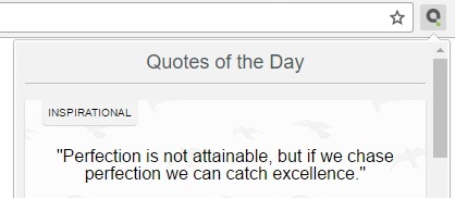
 Inspirational Quotes
-
 Leadership Quotes
-
 Life Quotes
-
 Love Quotes
-
 Morning Quotes
-
 Motivational Quotes
-
 Positive Quotes
-
 Romantic Quotes
-
 Success Quotes
-
 Time Quotes
-
 Travel Quotes
-
 Trust Quotes
-
 Truth Quotes
- Explore All Topics...


